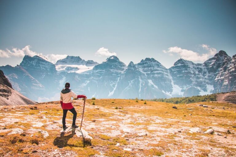
Introduction: Mountain Hikes in the USA
Mountain hiking is a thrilling outdoor activity that allows adventurers to immerse themselves in the breathtaking beauty of nature while challenging their physical and mental limits. With the United States being home to a diverse range of majestic mountains, hiking enthusiasts have ample opportunities to explore and conquer some of the most awe-inspiring trails in the world. In this article, we will provide an overview of the 10 best mountain hikes in the USA, showcasing their unique features, highlights, and difficulty levels, to inspire and guide fellow hikers in planning their next adventure.
Importance of mountain hiking as an outdoor activity:
Mountain hiking offers numerous benefits for both physical and mental well-being. It provides an excellent opportunity to engage in cardiovascular exercise, build strength, improve balance and coordination, and increase endurance. Hiking also allows for stress reduction and relaxation, as being surrounded by nature and breathing in fresh mountain air can have a calming effect on the mind and body. Additionally, hiking provides opportunities for socializing, bonding with fellow hikers, and creating lasting memories. The sense of accomplishment and satisfaction that comes with reaching the summit of a mountain after a challenging hike can also boost self-esteem and confidence.
10 Best Mountain Hikes in the USA
Embark on an awe-inspiring adventure with the 10 best mountain hikes in the USA, from the Rockies to the Appalachians.
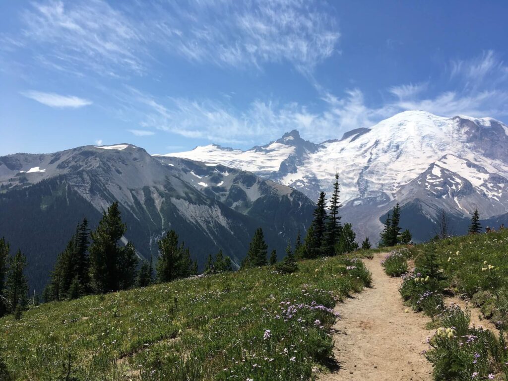
1: Mount Rainier
Located in Washington state, Mount Rainier is a towering stratovolcano that offers an unforgettable hiking experience for outdoor enthusiasts. With its impressive glaciers, wildflower meadows, and rugged landscapes, Mount Rainier is a must-visit destination for hikers seeking breathtaking views and challenging trails.
Description of the mountain hike:
Mount Rainier offers a variety of hiking options for all skill levels, ranging from easy day hikes to multi-day backpacking adventures. One of the most popular hikes is the Wonderland Trail, a 93-mile loop that circumnavigates the mountain and offers a challenging but rewarding experience for experienced hikers. The trail is typically completed in 10-14 days, depending on the pace of the hiker, and requires a backcountry permit.
Difficulty level and duration:
The Wonderland Trail is rated as strenuous, with steep ascents and descents, river crossings, and unpredictable weather conditions. Hikers should be prepared for rugged terrain, changing weather patterns, and potential hazards such as snowfields and rockfall. The trail requires excellent physical fitness, hiking experience, and proper gear. The duration of the hike depends on the pace of the hiker and the number of days spent on the trail, but it generally takes 10-14 days to complete the entire loop.
Highlights of the hike:
The Wonderland Trail offers awe-inspiring views of Mount Rainier’s glaciers, alpine meadows, old-growth forests, and pristine lakes. Hikers will have the opportunity to witness the mountain’s dramatic landscapes up close, including massive glaciers such as Emmons Glacier and Carbon Glacier. The trail also passes through stunning wildflower meadows, including the famous Spray Park, which bursts into a riot of colors during the summer months. Other highlights include panoramic vistas from high mountain passes, serene lakes such as Mystic Lake and Reflection Lake, and unique geological features such as volcanic formations and glacial valleys.
Tips and recommendations for hikers:
- Proper gear: Hikers should come prepared with appropriate gear, including sturdy hiking boots, waterproof clothing, layers for changing weather, trekking poles for stability, and camping equipment if planning to camp along the trail.
- Permits: Hikers must obtain a backcountry permit to hike the Wonderland Trail, which can be obtained through the National Park Service website or at the park’s visitor center. It is important to plan ahead and secure permits well in advance, as they are limited in number and can fill up quickly.
- Safety precautions: Hikers should be aware of the potential hazards of hiking in mountainous terrain, including changing weather conditions, steep slopes, river crossings, and wildlife encounters. It is crucial to follow park regulations, stay on designated trails, and carry necessary safety equipment, such as a first aid kit, map, and navigation tools.
- Leave No Trace: Hikers should practice Leave No Trace principles, including packing out all trash, minimizing campfire impacts, and respecting wildlife and other hikers. It is important to leave the wilderness as pristine as possible for future generations to enjoy.
- Hiking season: The best time to hike the Wonderland Trail is during the summer months of July to September when the snow has melted, and the weather is generally more predictable. However, hikers should be prepared for changing weather conditions and carry appropriate clothing and gear for all scenarios.
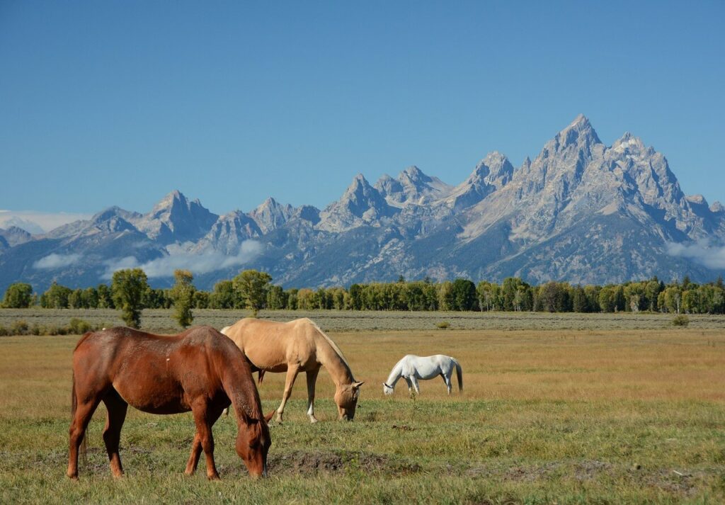
2: Grand Teton
Nestled in the breathtaking Teton Range of Wyoming, Grand Teton National Park is a mecca for mountain hikers seeking stunning vistas, pristine lakes, and rugged wilderness. With its jagged peaks, alpine meadows, and abundant wildlife, Grand Teton offers a world-class hiking experience for outdoor enthusiasts.
Description of the mountain hike:
One of the most popular hikes in Grand Teton National Park is the Cascade Canyon Trail, which offers stunning views of the iconic Teton peaks, including the Grand Teton itself. The trail starts at the Jenny Lake Visitor Center and follows the shores of Jenny Lake before ascending into Cascade Canyon. Hikers can choose to hike to Inspiration Point, which offers panoramic views of the Teton Range, or continue on to the Forks of Cascade Canyon for a longer and more challenging hike.
Difficulty level and duration:
The Cascade Canyon Trail is rated as moderate to strenuous, with elevation gains of up to 700 feet and a total round-trip distance of approximately 10 miles to the Forks of Cascade Canyon. The duration of the hike depends on the pace of the hiker and the chosen destination, but it generally takes 6-8 hours to complete the round-trip hike to the Forks of Cascade Canyon.
Highlights of the hike:
The Cascade Canyon Trail offers spectacular views of the Grand Teton peaks, as well as the picturesque Jenny Lake and its surrounding alpine meadows. Hikers will have the opportunity to spot abundant wildlife, including moose, marmots, pikas, and a variety of bird species. The trail also passes through lush forests, pristine streams, and rugged granite canyons, offering a diverse and stunning landscape. The highlight of the hike is reaching Inspiration Point or the Forks of Cascade Canyon, where hikers can marvel at the awe-inspiring beauty of the Teton Range up close.
Tips and recommendations for hikers:
- Proper gear: Hikers should come prepared with appropriate gear, including sturdy hiking boots, waterproof clothing, layers for changing weather, sunscreen, hat, sunglasses, and bear spray for wildlife encounters.
- Bear safety: Grand Teton National Park is home to grizzly bears and black bears, and hikers should take necessary precautions, such as carrying bear spray, making noise on the trail, and storing food properly to avoid attracting bears.
- Trail conditions: The trail can be rocky and uneven, and hikers should be prepared for steep ascents and descents. It is important to stay on designated trails, follow park regulations, and be mindful of potential hazards such as slippery rocks and river crossings.
- Weather: The weather in the Teton Range can be unpredictable, with sudden changes in temperature and weather patterns. Hikers should check the weather forecast before setting out and come prepared with appropriate clothing for all scenarios.
- Hiking season: The best time to hike the Cascade Canyon Trail is during the summer months of June to September when the trail is generally free of snow and accessible. However, hikers should be prepared for changing weather conditions and carry appropriate clothing and gear for all scenarios.
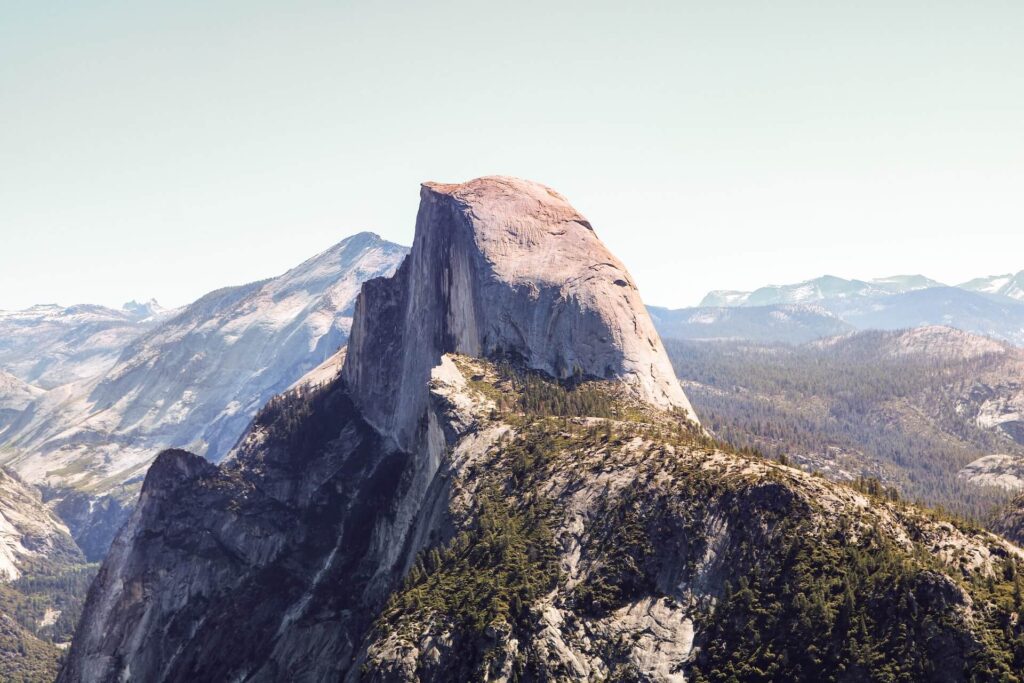
3: Yosemite Half Dome
Yosemite National Park, located in California’s Sierra Nevada Mountains, is renowned for its iconic granite cliffs, pristine valleys, and towering waterfalls. One of the most legendary hikes in Yosemite is the Half Dome hike, which offers a challenging and rewarding adventure for hikers seeking breathtaking views and an unforgettable experience.
Description of the mountain hike:
The Half Dome hike is a strenuous and technical hike that covers a distance of approximately 16-17 miles round trip. The hike begins at the Happy Isles Trailhead in Yosemite Valley and follows the Mist Trail, passing Vernal Fall and Nevada Fall along the way. From there, the trail continues through the Little Yosemite Valley before ascending the famous Half Dome cables, which provide handholds for hikers to climb the steep granite slope to the summit of Half Dome. The hike requires a permit from the National Park Service, and hikers should be prepared for a long and physically demanding day on the trail.
Difficulty level and duration:
The Half Dome hike is rated as strenuous and requires a high level of fitness and experience in hiking and rock climbing. The elevation gain is approximately 4,800 feet, and the hike can take anywhere from 10-14 hours to complete, depending on the pace of the hiker and the conditions on the trail.
Highlights of the hike:
The highlight of the Half Dome hike is reaching the summit of Half Dome, which offers unparalleled panoramic views of Yosemite Valley, including El Capitan, Yosemite Falls, and the surrounding high country. The hike also passes by two stunning waterfalls, Vernal Fall and Nevada Fall, which provide refreshing mist and scenic vistas along the way. The granite cliffs, pristine wilderness, and unique rock formations of Yosemite National Park create a stunning backdrop for this challenging hike, making it a bucket-list adventure for many hikers.
Tips and recommendations for hikers:
- Permit: Hikers must obtain a permit from the National Park Service to hike Half Dome. Permits are limited and require advanced planning, so hikers should check the Yosemite National Park website for permit availability and reservation details.
- Proper gear: Hikers should come prepared with appropriate gear, including sturdy hiking boots, gloves for the Half Dome cables, a backpack with plenty of water and snacks, sunscreen, hat, sunglasses, and extra layers for changing weather.
- Physical preparedness: The Half Dome hike requires a high level of fitness and endurance, as well as experience in hiking and rock climbing. Hikers should train and prepare themselves physically before attempting this challenging hike.
- Safety precautions: The Half Dome cables can be slippery and steep, and hikers should use caution and follow the posted safety guidelines. It is important to stay on the designated trail, use the provided cables and handholds, and be mindful of potential hazards such as loose rocks and changing weather conditions.
- Weather: The weather in Yosemite National Park can vary greatly depending on the season and elevation. Hikers should be prepared for changing weather conditions, including thunderstorms, high temperatures, and cold nights, and come prepared with appropriate clothing and gear.

4: Mount Whitney
Mount Whitney, located in California’s Sierra Nevada Mountains, is the highest peak in the contiguous United States, standing at 14,505 feet (4,421 meters) above sea level. Hiking to the summit of Mount Whitney is a challenging and exhilarating adventure that offers stunning panoramic views and a sense of accomplishment for hikers seeking to conquer one of the country’s tallest peaks.
Description of the mountain hike:
The hike to Mount Whitney’s summit begins at Whitney Portal, located near Lone Pine, California. The trail to the summit is approximately 22 miles round trip and involves a significant elevation gain of over 6,100 feet. Hikers will pass through various landscapes, including pine forests, alpine meadows, and rocky switchbacks, before reaching the summit. The hike is physically demanding and requires a high level of fitness and endurance.
Difficulty level and duration:
The hike to Mount Whitney’s summit is rated as strenuous due to its high elevation, long distance, and steep terrain. Hikers should be prepared for the effects of altitude, including potential altitude sickness, and should acclimatize properly before attempting the hike. The duration of the hike depends on the pace of the hiker and the conditions on the trail, but it typically takes 2-3 days to complete.
Highlights of the hike:
The highlight of the Mount Whitney hike is reaching the summit, which offers breathtaking panoramic views of the surrounding Sierra Nevada Mountains, including the peaks of the Sequoia and Kings Canyon National Parks. On a clear day, hikers can see as far as the White Mountains to the east and the Eastern Sierra to the west. The unique features of the hike include the striking granite cliffs, alpine lakes, and pristine wilderness that make up the landscape of the Eastern Sierra region.
Tips and recommendations for hikers:
- Permit: Hikers must obtain a permit from the Inyo National Forest for overnight camping or a day-use permit for day hikes to Mount Whitney. Permits are limited and require advanced planning, so hikers should check the Inyo National Forest website for permit availability and reservation details.
- Proper gear: Hikers should come prepared with appropriate gear for high-altitude hiking, including sturdy hiking boots, warm clothing, sunscreen, hat, sunglasses, plenty of water and snacks, and a map and compass or GPS for navigation. Hikers should also be prepared for potential changes in weather conditions, including cold temperatures, high winds, and thunderstorms.
- Acclimatization: Hikers should acclimatize properly to the high altitude before attempting the Mount Whitney hike to reduce the risk of altitude sickness. Spending a day or two at higher elevations, such as in the nearby town of Lone Pine or at higher camps along the trail, can help hikers adjust to the altitude.
- Safety precautions: Hikers should be aware of the potential hazards of high-altitude hiking, including altitude sickness, dehydration, and exposure to extreme weather conditions. Hikers should follow posted safety guidelines, stay on the designated trail, and be prepared to turn back if weather or health conditions deteriorate.
5: Mount Washington
Mount Washington, located in the White Mountains of New Hampshire, is the highest peak in the northeastern United States, standing at 6,288 feet (1,917 meters) above sea level. Hiking to the summit of Mount Washington offers a challenging and rewarding experience with stunning views and unique features that make it a popular destination for hikers and outdoor enthusiasts.
Description of the mountain hike:
The hike to Mount Washington’s summit can be approached from various trails, including the Tuckerman Ravine Trail, Lion Head Trail, and Ammonoosuc Ravine Trail, each with its own level of difficulty and duration. The trails vary in length, ranging from 4-8 miles one-way, and involve a significant elevation gain of over 4,000 feet. The hike is rated as moderate to strenuous, with steep sections, rocky terrain, and potential exposure to harsh weather conditions, including high winds and low temperatures.
Difficulty level and duration:
The hike to Mount Washington’s summit is rated as moderate to strenuous due to its elevation gain, steep terrain, and potential weather hazards. Hikers should be prepared for changing weather conditions and have a good level of fitness and hiking experience. The duration of the hike depends on the trail and the pace of the hiker, but it typically takes 6-8 hours for a one-way hike, not including time spent at the summit.
Highlights of the hike:
The highlights of the Mount Washington hike include the stunning panoramic views from the summit, which offers a 360-degree vista of the surrounding White Mountains, including the Presidential Range and the Mount Washington Observatory. The unique features of the hike include the Tuckerman Ravine, a glacial cirque with steep walls and unique alpine vegetation, and the famous cog railway, the world’s first mountain-climbing cog railway that has been in operation since 1869.
Tips and recommendations for hikers:
- Weather preparedness: Hikers should be prepared for changing weather conditions on Mount Washington, as the summit has some of the most severe weather in the world, including high winds, low temperatures, and sudden weather changes. Hikers should bring warm clothing, including layers, and waterproof gear, and be prepared to turn back if weather conditions deteriorate.
- Proper gear: Hikers should come prepared with appropriate gear for mountain hiking, including sturdy hiking boots, warm clothing, plenty of water and snacks, a map and compass or GPS for navigation, and a headlamp or flashlight in case of hiking in low light conditions. Hikers should also be prepared for potential changes in weather conditions and have gear suitable for the season.
- Safety precautions: Hikers should follow posted safety guidelines, stay on the designated trail, and be cautious of steep and rocky sections of the trail. Hikers should also be aware of the potential hazards of hiking in high elevations, including altitude sickness, dehydration, and exposure to extreme weather conditions.
- Hiking permits: Some trails on Mount Washington require a hiking permit, so hikers should check the regulations and obtain the necessary permits before embarking on the hike.
6: Rocky Mountain National Park
Rocky Mountain National Park, located in Colorado, USA, is known for its breathtaking mountain scenery, diverse ecosystems, and abundant wildlife. With over 350 miles of trails, it offers a wide range of hiking options, including hikes to high mountain peaks, alpine lakes, and pristine meadows.
Description of the mountain hike:
The mountain hikes in Rocky Mountain National Park vary in difficulty, duration, and location. Some of the popular mountain hikes include Longs Peak, Flattop Mountain, and Hallett Peak. These hikes typically involve steep ascents, rocky terrain, and significant elevation gains, ranging from 2,000 to 4,000 feet. The difficulty level of the hikes can vary from moderate to strenuous, depending on the trail and weather conditions. The duration of the hikes also varies, ranging from 4-12 hours round-trip, depending on the trail and the hiker’s pace.
Highlights of the hike:
The highlights of hiking in Rocky Mountain National Park include the stunning scenic vistas of snow-capped peaks, alpine lakes, and lush valleys. Unique features of the park include the pristine meadows filled with wildflowers, rugged granite cliffs, and diverse wildlife, including elk, bighorn sheep, and marmots. Points of interest along the trails may include scenic overlooks, historic sites, and geological formations, such as glacial cirques and moraines.
Tips and recommendations for hikers:
- Acclimatization: Rocky Mountain National Park has high elevations ranging from 7,500 to over 14,000 feet, so hikers should take time to acclimate to the altitude to avoid altitude sickness. It’s recommended to spend a day or two at lower elevations before attempting high mountain hikes.
- Weather preparedness: Weather in the mountains can be unpredictable, with rapid changes in temperature and weather conditions. Hikers should be prepared for changing weather, including rain, snow, and lightning. It’s important to bring warm clothing, and rain gear, and be aware of weather forecasts before heading out.
- Proper gear: Hikers should wear sturdy hiking boots, and bring plenty of water, snacks, a map, and a compass or GPS for navigation. Hiking poles can also be helpful on steep and rocky terrain. It’s important to pack out all trash and follow Leave No Trace principles.
- Safety precautions: Hikers should stay on designated trails, be cautious of steep and rocky sections, and be mindful of wildlife, including bears and mountain lions, which are present in the park. Hikers should also be prepared for potential hazards such as altitude sickness, dehydration, and wildlife encounters.
- Hiking permits: Some hikes in Rocky Mountain National Park may require a hiking permit, so hikers should check the regulations and obtain the necessary permits before embarking on the hike.
- Time management: Hikers should start early in the day to allow enough time for the hike, especially for longer hikes, and plan their route accordingly. It’s important to be aware of sunset times and not to hike after dark.

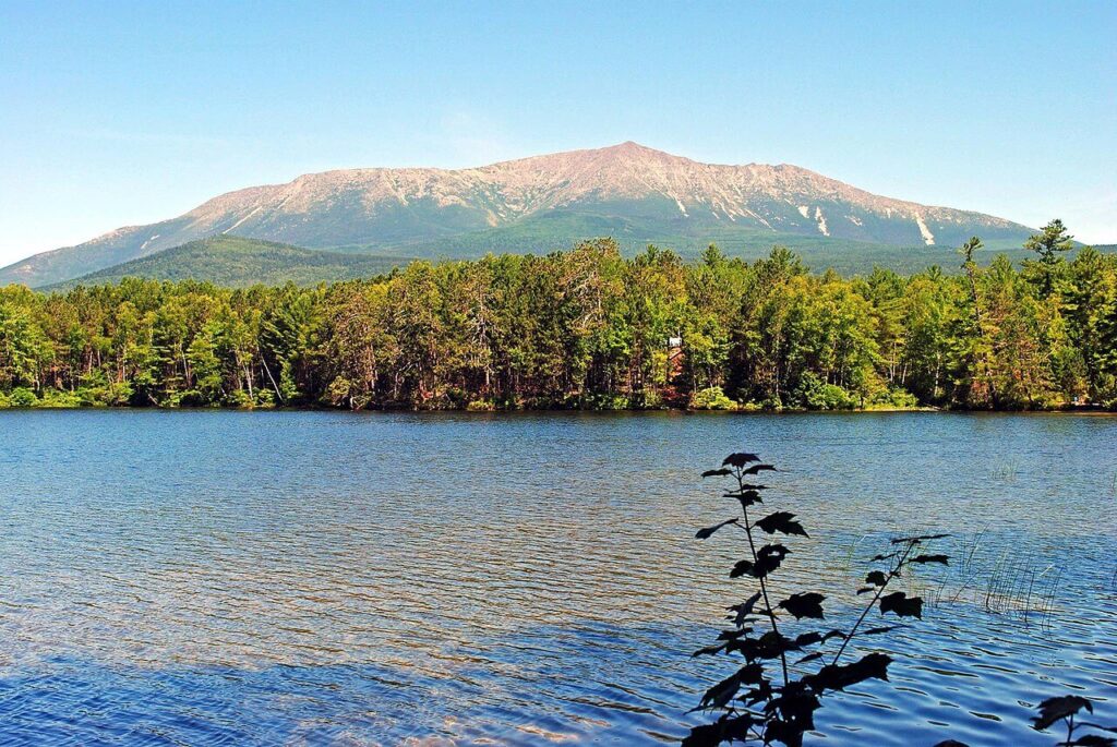
7: Mount Marcy
Mount Marcy, located in the Adirondack Mountains of upstate New York, is the highest peak in the state and offers a challenging and rewarding mountain hiking experience. With an elevation of 5,344 feet, Mount Marcy is a popular destination for hikers seeking a challenging summit hike with stunning views of the surrounding wilderness.
Description of the mountain hike:
The hike to Mount Marcy is rated as challenging and is recommended for experienced hikers due to its rugged terrain and long distance. The most common starting point for the hike is the Adirondak Loj, which is located near Lake Placid. The round-trip distance for the hike is approximately 14.8 miles, and the hike can take anywhere from 8-12 hours to complete, depending on the hiker’s pace and trail conditions.
The trail to Mount Marcy involves steep ascents, rocky terrain, and several stream crossings. The trail passes through dense forests of pine and hardwoods, traverses alpine meadows, and climbs above the treeline, offering panoramic views of the surrounding peaks and valleys. The summit of Mount Marcy is treeless and offers breathtaking views of the High Peaks region of the Adirondacks.
Highlights of the hike:
The highlights of hiking Mount Marcy include the scenic vistas of the surrounding High Peaks region, including the Great Range, the Dix Range, and the MacIntyre Range. The summit of Mount Marcy offers panoramic views of the surrounding wilderness, including pristine lakes, rugged peaks, and dense forests. The unique features of the hike include the alpine meadows, rock formations, and the challenging terrain that makes it a rewarding adventure for experienced hikers.
Tips and recommendations for hikers:
- Proper gear: Hikers should wear sturdy hiking boots, and bring plenty of water, snacks, a map, and a compass or GPS for navigation. It’s important to pack warm clothing, as temperatures can be much cooler at higher elevations, even in the summer. Hiking poles can also be helpful on steep and rocky terrain.
- Weather preparedness: Weather in the Adirondacks can be unpredictable, with rapid changes in temperature and weather conditions. Hikers should be prepared for changing weather, including rain, fog, and cooler temperatures. It’s important to bring rain gear, extra layers, and be aware of weather forecasts before heading out.
- Safety precautions: Hikers should stay on designated trails, be cautious of steep and rocky sections, and be prepared for potential hazards such as slippery rocks and stream crossings. Hikers should also be aware of wildlife, such as bears and moose, which are present in the area.
- Hiking permits: Hikers are required to obtain a free day-use permit from the Adirondack Loj for hiking Mount Marcy to help manage the impact on the fragile alpine vegetation. It’s important to obtain the necessary permits and follow any regulations in the area.
- Physical preparedness: Hiking Mount Marcy is a strenuous hike that requires good physical fitness and endurance. Hikers should be prepared for a long day of hiking with challenging terrain and pace themselves accordingly. It’s important to be realistic about your abilities and fitness level before attempting this hike.
8: Mount Katahdin
Mount Katahdin, located in Baxter State Park in northern Maine, is the highest peak in the state and is known for its rugged terrain and stunning vistas. This iconic mountain offers a challenging and rewarding hiking experience for outdoor enthusiasts.
Description of the mountain hike:
The hike to Mount Katahdin is rated as challenging and is recommended for experienced hikers due to its difficult and exposed terrain. There are several trails that lead to the summit of Mount Katahdin, including the popular Knife Edge Trail, which is known for its narrow ridge and steep drop-offs. The round-trip distance for the hike varies depending on the trail chosen, ranging from 8 to 11 miles, and the hike can take anywhere from 8-12 hours to complete, depending on the hiker’s pace and trail conditions.
The trails to Mount Katahdin involve steep ascents, rocky terrain, and exposed sections that require careful footing and scrambling. The trails pass through dense forests, traverse rocky ridges, and offer breathtaking views of the surrounding wilderness. The summit of Mount Katahdin is above the treeline and offers panoramic views of the surrounding peaks, lakes, and valleys.
Highlights of the hike:
The highlights of hiking Mount Katahdin include the scenic vistas of the surrounding wilderness, the rugged beauty of Baxter State Park, the sparkling lakes, and the vast forests. The unique features of the hike include the Knife Edge Trail, a narrow and exposed ridge that offers a thrilling hiking experience and panoramic views of the surrounding landscape. The summit of Mount Katahdin, known as Baxter Peak, is the highest point in Maine and offers stunning views of the surrounding area.
Tips and recommendations for hikers:
- Proper gear: Hikers should wear sturdy hiking boots, and bring plenty of water, snacks, a map, and a compass or GPS for navigation. It’s important to pack warm clothing, as temperatures can be cooler at higher elevations, even in the summer. Hiking poles and gloves can also be helpful for navigating steep and rocky sections.
- Weather preparedness: Weather in northern Maine can be unpredictable, with rapid changes in temperature and weather conditions. Hikers should be prepared for changing weather, including rain, fog, and cooler temperatures. It’s important to bring rain gear, extra layers, and be aware of weather forecasts before heading out.
- Safety precautions: Hikers should stay on designated trails, be cautious of steep and rocky sections, and be prepared for potential hazards such as slippery rocks and exposed ridges. The Knife Edge Trail requires careful footing and should only be attempted by experienced hikers with proper gear and skills. Hikers should also be aware of wildlife, such as moose and black bears, which are present in the area.
- Hiking permits: Hikers are required to obtain a free day-use permit from Baxter State Park for hiking Mount Katahdin to help manage the impact on the fragile alpine vegetation. It’s important to obtain the necessary permits and follow any regulations in the area.
- Physical preparedness: Hiking Mount Katahdin is a strenuous hike that requires good physical fitness and endurance. Hikers should be prepared for a long day of hiking with challenging terrain and pace themselves accordingly. It’s important to be realistic about your abilities and fitness level before attempting this hike.

9: Mount St. Helens
Mount St. Helens, located in Washington state, is an active stratovolcano that is famous for its historic eruption in 1980. Today, it offers a unique hiking experience with breathtaking views of the volcano’s crater and the surrounding landscape.
Description of the mountain hike:
The hike to Mount St. Helens is rated as moderately challenging and is suitable for hikers with some experience in hiking and outdoor activities. The most popular trail to the summit is the Monitor Ridge Trail, which starts at the Climbers Bivouac and covers a round-trip distance of approximately 10 miles. The duration of the hike can vary depending on the hiker’s pace and trail conditions but typically takes 6-8 hours to complete.
The trail starts in a dense forest and gradually ascends to higher elevations. As hikers gain elevation, the trail becomes more challenging, with rocky terrain, loose volcanic ash, and steep sections. Hikers will pass through different ecological zones, including lush forests, barren landscapes, and rocky ridges. The highlight of the hike is reaching the crater rim of Mount St. Helens, where hikers can witness the aftermath of the 1980 eruption, including the steaming lava dome and the vast crater.
Highlights of the hike:
The highlights of hiking Mount St. Helens include the scenic vistas of the surrounding landscape, including panoramic views of the crater, the blast zone, and the surrounding mountains. The unique features of the hike include the opportunity to witness the destructive power of a volcanic eruption up close, with remnants of the 1980 eruption still visible on the landscape. Hikers can also learn about the geology, ecology, and history of the area through interpretive signs along the trail, providing a unique educational experience.
Tips and recommendations for hikers:
- Necessary gear: Hikers should wear sturdy hiking boots, bring plenty of water, snacks, sunscreen, sunglasses, and a hat. The trail can be dusty and rocky, so wearing gaiters or long pants is recommended to protect against abrasions from loose volcanic ash. Hiking poles can also be helpful for navigating steep sections and loose terrain.
- Weather preparedness: Weather on Mount St. Helens can be unpredictable, with rapid changes in temperature and weather conditions. Hikers should be prepared for changing weather, including rain, snow, and cooler temperatures, even in the summer. It’s important to bring appropriate clothing layers, rain gear, and check weather forecasts before heading out.
- Safety precautions: Hikers should stay on designated trails, follow any posted signs or warnings, and be cautious of loose volcanic ash and rocks. The Monitor Ridge Trail has some steep sections and requires careful footing, especially during descent. Hikers should also be aware of potential hazards such as rockfall, avalanches, and sudden weather changes.
- Permits: Hiking to the summit of Mount St. Helens requires a climbing permit, which can be obtained through the Mount St. Helens Institute or the Mount St. Helens National Volcanic Monument. It’s important to obtain the necessary permits and follow any regulations in the area.
- Physical preparedness: Hiking Mount St. Helens involves significant elevation gain and challenging terrain. Hikers should be prepared with good physical fitness and endurance, as well as acclimatize to higher elevations if not accustomed to hiking at higher altitudes. It’s important to pace oneself and be prepared for a strenuous hike.
- Leave No Trace: Hikers should follow Leave No Trace principles, including packing out all trash, respecting wildlife and vegetation, and staying on designated trails to minimize the impact on the fragile volcanic landscape.
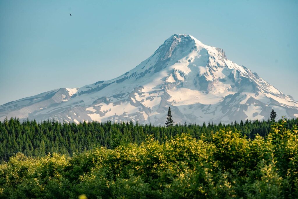
10: Mount Hood
Mount Hood, located in Oregon, is a dormant stratovolcano and the highest peak in the state. It offers a variety of hiking opportunities for outdoor enthusiasts, from scenic day hikes to challenging summit climbs.
Description of the mountain hike:
The hike to Mount Hood can vary in difficulty level and duration depending on the chosen trail. One of the most popular trails is the Timberline Trail, which circles around the mountain and offers breathtaking views of the surrounding landscape. The difficulty level of this trail is rated as moderate, suitable for hikers with some experience in hiking and outdoor activities. The duration of the hike can range from a day hike covering a section of the trail, to multiple days for those wishing to complete the entire loop, which is approximately 40 miles long.
The Timberline Trail starts at Timberline Lodge, a historic lodge located at an elevation of 6,000 feet on Mount Hood. The trail winds through alpine meadows, dense forests, and rocky ridges, offering stunning vistas of the mountain’s glaciers, valleys, and surrounding peaks. Hikers will pass through unique features such as volcanic rock formations, waterfalls, and picturesque creeks. The highlight of the hike is reaching higher elevations, where hikers can enjoy panoramic views of the surrounding landscape, including the Columbia River Gorge, Mount Adams, and Mount Rainier on clear days.
Highlights of the hike:
The highlights of hiking Mount Hood include the scenic vistas of the surrounding landscape, with stunning views of the mountain’s glaciers, valleys, and surrounding peaks. The unique features of the hike include the opportunity to experience diverse ecosystems, from lush forests to alpine meadows, and witness the effects of glaciation on the landscape. Hikers can also enjoy the historic Timberline Lodge, a renowned landmark known for its rustic charm and beautiful architecture.
Tips and recommendations for hikers:
- Necessary gear: Hikers should wear sturdy hiking boots, and bring plenty of water, snacks, sunscreen, sunglasses, and a hat. Weather on Mount Hood can change rapidly, so bringing appropriate clothing layers, including rain gear and warm clothing, is essential. Hiking poles can be helpful for navigating rocky terrain and river crossings.
- Weather preparedness: Weather on Mount Hood can be unpredictable, with rapid changes in temperature and weather conditions, especially at higher elevations. Hikers should be prepared for changing weather, including rain, snow, and cooler temperatures, even in the summer. It’s important to check weather forecasts, trail conditions, and be prepared with the right gear.
- Safety precautions: Hikers should stay on designated trails, follow any posted signs or warnings, and be cautious of loose rocks and slippery surfaces. The higher elevations of Mount Hood can have steep sections and exposed terrain, so hikers should exercise caution and be mindful of their footing. It’s also important to be aware of potential hazards such as avalanches, crevasses, and changing weather conditions.
- Permits: Some trails on Mount Hood require a recreation pass or a wilderness permit, depending on the specific route. It’s important to check and obtain the necessary permits before heading out and follow any regulations in the area.
- Physical preparedness: Hiking Mount Hood involves significant elevation gain and challenging terrain. Hikers should be prepared with good physical fitness and endurance, as well as acclimatize to higher elevations if not accustomed to hiking at higher altitudes. It’s important to pace oneself and be prepared for a strenuous hike.

Additional Resources
When planning mountain hikes in the USA, it’s essential to gather as much information as possible to ensure a safe and enjoyable experience. Here are some recommendations for further reading, websites, and other resources that can provide valuable information for hikers:
- National Park Service (NPS) Website: The NPS manages many of the national parks in the USA, including popular hiking destinations such as Yosemite, Rocky Mountain, and Grand Canyon National Parks. The NPS website (www.nps.gov) provides detailed information on park regulations, safety tips, trail maps, and other important information for planning hikes in national parks.
- U.S. Forest Service (USFS) Website: The USFS manages national forests and grasslands across the USA, which offer numerous hiking opportunities. The USFS website (www.fs.usda.gov) provides information on trail conditions, permits, and safety tips for hiking in national forests.
- American Hiking Society (AHS) Website: The AHS (www.americanhiking.org) is a non-profit organization that provides resources and information on hiking safety, trail etiquette, and trail advocacy. Their website offers helpful tips on planning and preparing for hikes, as well as information on hiking gear, navigation, and Leave No Trace principles.
- Hiking Guidebooks: There are numerous guidebooks available that provide detailed information on hiking trails in the USA. Some popular series include the “Falcon Guides” and “Lonely Planet” guidebooks, which offer comprehensive trail descriptions, maps, and safety tips for various hiking destinations.
- Online Forums and Communities: There are many online forums and communities where hikers can find valuable information and connect with fellow hikers. Websites such as www.backpacker.com, www.hikingproject.com, and www.alltrails.com provide trail information, reviews, and safety tips from experienced hikers.
Safety tips, trail maps, and other helpful information for hikers:
- Always check weather forecasts and trail conditions before heading out, and be prepared for changing weather conditions, including rain, snow, and temperature fluctuations.
- Carry sufficient water, food, and snacks, as well as appropriate clothing layers, sunscreen, sunglasses, and a hat.
- Bring a map and compass, and know how to use them. Familiarize yourself with the trail route and be aware of any potential hazards along the way.
- Inform someone of your hiking plans, including your itinerary, expected return time, and emergency contact information.
- Follow Leave No Trace principles, including packing out all trash, respecting wildlife and vegetation, and staying on designated trails.
- Be cautious of wildlife, including bears, snakes, and other potentially dangerous animals. Research the wildlife in the area beforehand and take necessary precautions.
Acknowledgments:
This comprehensive guide would not have been possible without the invaluable resources provided by national parks, national forests, hiking organizations, guidebooks, online forums, and the hiking community as a whole. Their dedication to promoting hiking safety, providing trail information, and preserving our natural resources is greatly appreciated.
Conclusion:
Exploring the mountains of the USA can be an exhilarating and rewarding experience for hikers. From iconic peaks like Mount Rainier and Mount Whitney to lesser-known gems like Mount Katahdin and Mount St. Helens, the country offers a diverse range of mountain hikes for all levels of hikers.
When planning a mountain hike, it’s crucial to do thorough research and gather information from reliable resources such as national park and forest websites, hiking organizations, guidebooks, online forums, and experienced hikers. This information can help hikers make informed decisions about the location, difficulty level, duration, and necessary gear for their hike.
Safety should always be a top priority when hiking in the mountains. Hikers should be prepared for changing weather conditions, carry appropriate gear and clothing, follow Leave No Trace principles, and be aware of potential hazards. Informing someone of your hiking plans and knowing how to use a map and compass are also important safety precautions.
The breathtaking scenic vistas, unique features, and points of interest along the mountain hikes in the USA make for unforgettable experiences. Whether it’s witnessing a sunrise from the summit of Mount Washington, marveling at the panoramic views from Rocky Mountain National Park, or exploring the volcanic landscape of Mount St. Helens, the beauty of nature is abundant.
In conclusion, the mountains of the USA offer a wealth of opportunities for hikers to immerse themselves in the beauty of the wilderness and experience the thrill of summiting majestic peaks. With careful planning, preparation, and adherence to safety measures, hikers can embark on memorable adventures and create lasting memories in these spectacular mountain destinations. Happy hiking!
Read more articles here.