
Introduction
Hiking is a great way to get exercise, enjoy the outdoors, and explore new places. But it can also be challenging, especially if you’re not familiar with the area. That’s where hiking apps come in.
Hiking apps can help you find the best trails for your skill level, plan your route, and stay safe on the trail. They can also provide you with information about the trail, such as the length, difficulty, and elevation gain.
If you’re looking for a hiking app, there are a lot of great options to choose from. In this article, we’ll take a look at the 7 best hiking apps of 2023. We’ll cover both free and paid apps, so you can find the perfect one for your needs.
We’ll also discuss the benefits of using a hiking app, what to look for in a good hiking app, and the drawbacks of using hiking apps. So whether you’re a beginner or a seasoned hiker, read on to learn more about the best hiking apps of 2023!
Criteria for Selection
When evaluating the best hiking apps for 2023, several important criteria have been considered to ensure a comprehensive and reliable selection. The following criteria highlight the key aspects that have been taken into account during the selection process:
User Interface and Experience:
A user-friendly and intuitive interface is crucial for a hiking app to provide a seamless experience. The app should be easy to navigate, with clear menus, icons, and a well-designed layout. Intuitive controls and visual aesthetics contribute to a positive user experience.
Features and Functionality:
The selected hiking apps offer a range of features and functionalities to enhance the hiking experience. These may include GPS tracking, trail mapping, elevation profiles, real-time weather updates, geolocation, compass, route planning, and information about points of interest along the trail. The apps should provide comprehensive and accurate data to assist hikers effectively.

Offline Capability:
Hiking often takes place in remote areas where internet connectivity may be limited or unavailable. The apps chosen prioritize offline capability, allowing users to access maps, trail information, and navigation features without relying on an internet connection. Offline maps and saved data ensure hikers can navigate and explore even in areas with poor signal reception.
Navigation and Mapping Accuracy:
Accurate navigation and mapping are vital for hikers to stay on track and avoid getting lost. The selected apps have been evaluated for their navigation accuracy, including reliable GPS tracking, precise trail mapping, and up-to-date trail information. The apps should provide clear and accurate directions, helping hikers navigate complex trail systems and unfamiliar terrains.
Community and Social Integration:
Community and social integration within hiking apps foster a sense of shared experiences, allow hikers to connect with fellow enthusiasts, and provide valuable insights and recommendations. The selected apps incorporate features such as user-generated reviews, ratings, photos, and trail logs, enabling hikers to benefit from the collective knowledge and experiences of a hiking community.
Review of the Top 7 Hiking Apps
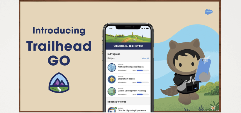
1: Trailhead+
Trailhead+ is a subscription-based learning platform that offers a wide range of courses on Salesforce, cloud computing, and other business-related topics. The platform is designed to help users learn new skills, earn certifications, and advance their careers.
Key Features
- Courses: Trailhead+ offers a wide range of courses on Salesforce, cloud computing, and other business-related topics. Courses are available at all levels, from beginner to advanced.
- Certifications: Trailhead+ offers a variety of certifications that can help users advance their careers. Certifications are available in a variety of areas, including Salesforce, cloud computing, and business.
- Community: Trailhead+ has a large and active community of users who can help each other learn and grow. The community is a great resource for finding answers to questions, getting help with projects, and networking with other professionals.
Pros:
- Wide range of courses
- Variety of certifications
- Active community
- Affordable subscription price
Cons:
- Some courses can be difficult
- Not all courses are relevant to everyone
- Some courses may not be up-to-date
Overall, Trailhead+ is a great resource for anyone who wants to learn new skills, earn certifications, and advance their career. The platform offers a wide range of courses, certifications, and a supportive community.
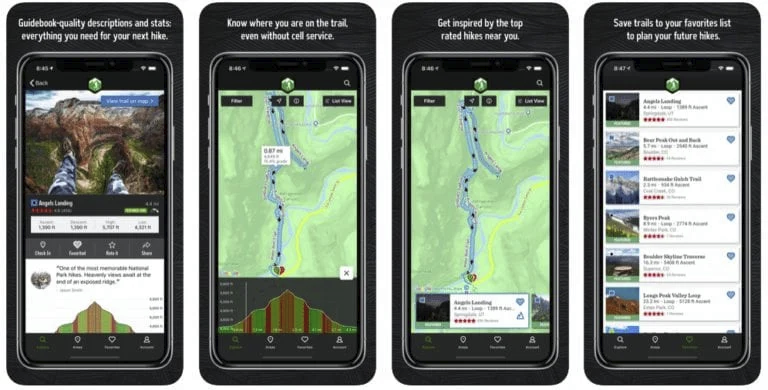
2: AllTrails Pro
AllTrails Pro is a subscription-based service that offers a variety of features that can be helpful for hikers, bikers, and other outdoor enthusiasts. Some of the key features of AllTrails Pro include:
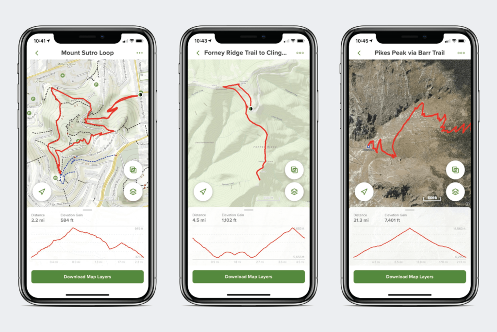
- Offline maps: This feature allows you to download maps for offline use, which can be helpful if you’re going to be hiking or biking in an area with poor cell reception.
- Leaderboard: This feature allows you to track your progress against other users on the same trail.
- Route planning: This feature allows you to plan your hikes or bike rides in advance, and it will even suggest routes based on your fitness level and interests.
- Weather: This feature provides real-time weather updates for your location, so you can make sure you’re prepared for the conditions.
- Photo sharing: This feature allows you to share photos of your hikes or bike rides with other users on the AllTrails community.
Overall, AllTrails Pro is a great option for hikers, bikers, and other outdoor enthusiasts who want access to a variety of features that can help them plan and enjoy their adventures.
Here are some pros and cons of AllTrails Pro:
Pros:
- Offline maps
- Leaderboard
- Route planning
- Weather
- Photo sharing
Cons:
- Subscription fee
- Some features are not available in all areas
If you’re looking for a comprehensive app that can help you plan and enjoy your outdoor adventures, AllTrails Pro is a great option. However, if you’re not sure if you’ll use all of the features, you may want to consider the free version of the app first.
3: Gaia GPS
Gaia GPS is a popular outdoor navigation app that offers a variety of features for hikers, bikers, and other outdoor enthusiasts. Some of the key features of Gaia GPS include:
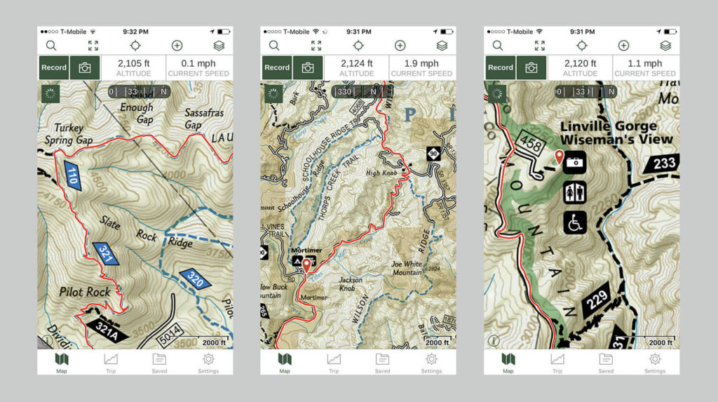
- Offline maps: Gaia GPS allows you to download maps for offline use, which can be helpful if you’re going to be hiking or biking in an area with poor cell reception.
- Route planning: Gaia GPS allows you to plan your hikes or bike rides in advance, and it will even suggest routes based on your fitness level and interests.
- Waypoint creation: Gaia GPS allows you to create waypoints to mark specific locations, such as trailheads, campsites, or water sources.
- Track recording: Gaia GPS allows you to record your hikes or bike rides, so you can track your progress and see where you’ve been.
- Weather: Gaia GPS provides real-time weather updates for your location, so you can make sure you’re prepared for the conditions.
- Photo sharing: Gaia GPS allows you to share photos of your hikes or bike rides with other users on the Gaia GPS community.
Overall, Gaia GPS is a great option for hikers, bikers, and other outdoor enthusiasts who want access to a variety of features that can help them plan and enjoy their adventures.
Here are some pros and cons of Gaia GPS:
Pros:
- Offline maps
- Route planning
- Waypoint creation
- Track recording
- Weather
- Photo sharing
- Customizable maps
- Extensive trail database
- User-friendly interface
Cons:
- Subscription fee
- Some features are not available in all areas
- Can be difficult to learn at first
If you’re looking for a comprehensive app that can help you plan and enjoy your outdoor adventures, Gaia GPS is a great option. However, if you’re not sure if you’ll use all of the features, you may want to consider the free version of the app first.
4: Komoot
Komoot is a route planning and navigation app that is designed for outdoor enthusiasts. It offers a variety of features that can help you plan and enjoy your adventures, including:
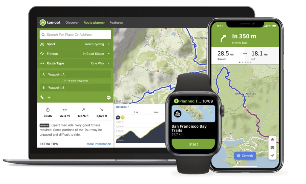
- Offline maps: Komoot allows you to download maps for offline use, which can be helpful if you’re going to be hiking or biking in an area with poor cell reception.
- Route planning: Komoot allows you to plan your hikes or bike rides in advance, and it will even suggest routes based on your fitness level and interests.
- Waypoint creation: Komoot allows you to create waypoints to mark specific locations, such as trailheads, campsites, or water sources.
- Track recording: Komoot allows you to record your hikes or bike rides, so you can track your progress and see where you’ve been.
- Weather: Komoot provides real-time weather updates for your location, so you can make sure you’re prepared for the conditions.
- Photo sharing: Komoot allows you to share photos of your hikes or bike rides with other users on the Komoot community.
- Voice navigation: Komoot offers voice navigation, which can be helpful if you’re hiking or biking in an area with a lot of noise.
- Community: Komoot has a large and active community of users who share routes, photos, and tips.
Overall, Komoot is a great option for hikers, bikers, and other outdoor enthusiasts who want access to a variety of features that can help them plan and enjoy their adventures.
Here are some pros and cons of Komoot:
Pros:
- Offline maps
- Route planning
- Waypoint creation
- Track recording
- Weather
- Photo sharing
- Voice navigation
- Community
- User-friendly interface
Cons:
- Subscription fee
- Some features are not available in all areas
- Can be difficult to learn at first
If you’re looking for a comprehensive app that can help you plan and enjoy your outdoor adventures, Komoot is a great option. However, if you’re not sure if you’ll use all of the features, you may want to consider the free version of the app first.
5: Hiking Project
Hiking Project is a free app that provides information on hiking trails all over the world. It has over 74,000 trails in its database, and it includes detailed information on each trail, such as the length, difficulty, elevation gain, and reviews from other hikers. Hiking Project also allows users to create their own custom trails.
Here are some of the key features of Hiking Project:
- Trail information: Hiking Project provides detailed information on each trail in its database, including the length, difficulty, elevation gain, and reviews from other hikers.
- Custom trails: Hiking Project allows users to create their own custom trails. This is a great way to find new trails to explore, or to create a trail that is tailored to your specific needs.
- Offline maps: Hiking Project allows users to download maps for offline use. This is a great way to use the app in areas with poor cell reception.
- Navigation: Hiking Project provides turn-by-turn navigation for all of its trails. This is a great way to stay on track, even if you are not familiar with the area.
- Community: Hiking Project has a large and active community of users. This is a great place to find information on new trails, get advice from other hikers, and share your own experiences.
Here are some of the pros and cons of Hiking Project:
Pros:
- Free
- Extensive trail database
- Detailed trail information
- Custom trail creation
- Offline maps
- Navigation
- Active community
Cons:
- Some features are not available in all areas
- Can be difficult to learn at first
- Not as user-friendly as some other apps
Overall, Hiking Project is a great app for hikers of all levels. It is free to use, has a comprehensive trail database, and provides detailed information on each trail. Hiking Project is also a great way to connect with other hikers and share your own experiences.
6: MapMyHike
MapMyHike is a mobile app that allows users to track their hikes, runs, and bike rides. It offers a variety of features:

Key Features
Some of the key features of MapMyHike include:
- GPS tracking: MapMyHike uses GPS to track your location and create a detailed map of your hike.
- Route planning: MapMyHike allows you to plan your hikes in advance. You can choose from a variety of pre-made routes or create your own.
- Audio cues: MapMyHike provides audio cues to help you stay on track. These cues can include distance, time, and elevation.
- Social sharing: MapMyHike allows you to share your hikes with friends and family. You can also compete with other users on the leaderboard.
- Leaderboards: MapMyHike has a leaderboard that tracks your progress and compares it to other users.
- Training plans: MapMyHike offers a variety of training plans to help you improve your hiking performance.
Here are some of the pros and cons of MapMyHike:
Pros:
- GPS tracking is accurate and reliable.
- Route planning is easy and intuitive.
- Audio cues are helpful and informative.
- Social sharing is a great way to connect with other hikers.
- Leaderboards provide motivation and competition.
- Training plans are effective and easy to follow.
Cons:
- The app can be expensive.
- The interface can be cluttered and confusing.
- The app can be slow at times.
- The app can drain your battery quickly.
Overall, MapMyHike is a great app for hikers of all levels. It offers a variety of features that make it easy to track your hikes, plan your routes, and stay motivated. However, the app can be expensive and the interface can be cluttered.
7: PeakVisor
PeakVisor is a mobile app that helps you identify mountains and other features in the natural world. It uses your phone’s camera to identify mountains, lakes, rivers, and other features. It also provides information about the features, such as their height, distance, and difficulty level.

Key Features
Some of the key features of PeakVisor include:
- Image recognition: PeakVisor uses your phone’s camera to identify mountains and other features in the natural world.
- Information: PeakVisor provides information about the features, such as their height, distance, and difficulty level.
- 3D models: PeakVisor provides 3D models of mountains and other features. This can be helpful for planning hikes and climbs.
- Offline maps: PeakVisor allows you to download maps for offline use. This can be helpful if you are hiking or climbing in an area with no cell service.
- Community: PeakVisor has a community of users who share photos, tips, and information about mountains and other features.
Here are some of the pros and cons of PeakVisor:
Pros:
- Easy to use
- Accurate identification
- Provides information about features
- 3D models
- Offline maps
- Active community
Cons:
- Can be expensive
- Requires a good internet connection for image recognition
- Not as accurate in areas with poor visibility
Overall, PeakVisor is a great app for hikers, climbers, and nature lovers. It is easy to use and provides accurate identification of mountains and other features. It also provides information about the features, such as their height, distance, and difficulty level.

Conclusion
In conclusion, the 7 best hiking apps for 2023 offer a wide range of features and functionalities to enhance your hiking experiences. With user-friendly interfaces, offline capabilities, accurate navigation, and community integration, these apps provide invaluable tools for hikers of all levels. From Trailhead+ with its extensive trail database and personalized recommendations to AllTrails Pro, Gaia GPS, and Komoot, each app offers unique strengths to cater to different preferences and needs.
These apps empower hikers to discover new trails, plan routes, track progress, and engage with a vibrant hiking community. As technology continues to advance, it is exciting to anticipate further innovations in hiking apps, promising even more immersive and personalized experiences. By leveraging these top hiking apps, you can make the most of your outdoor adventures, ensuring that you have the information, resources, and support to navigate trails, discover hidden gems, and embrace the beauty of nature.
Read more articles here.